May 1, 2015

Day 74

Temperature: 73.9 °F,  feels like 76 °F
Humidity: 27%
Dew Point: 39 °F
Wind: 2.2 mph N with 7.6 mph gusts
Pressure: 30.08 in
Visibility: 10 miles
Cover: Overcast
Observation: 12:30 PM
Moon: Waxing Gibbous, 94% visible


Source: http://wxug.us/19tg2


This morning was pretty sunny and clear but in the last two hours or so, it has become increasingly cloudy and now there is a near solid cover of light gray high altitude clouds. There was a spike in temperature earlier hitting around 73 °F but the temperature has been slowly declining with the cloud cover. The cause for this was a warm front that passed through quickly and is being replaced with a cold front that has moisture and rain coming from the North/northwest. There is currently a 20% chance the rain will actually fall in our area, but the cloud cover and moisture will be sticking around and raising ground temperatures tonight and into tomorrow. This build up of energy along with combating fronts will likely produce a thunderstorm on Sunday afternoon evening. Can't wait!


April 30, 2015

Day 73

Temperature: 67 °F,  feels like 67 °F
Humidity: 28%
Dew Point: 33 °F
Wind: 2.2 mph N with 6 mph gusts
Pressure: 30.03 in
Visibility: 10 miles
Cover: Clear
Observation: 4:30 PM
Moon: Waxing Gibbous, 90% visible


Source: http://wxug.us/19tg2

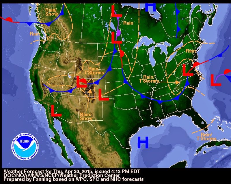
Today has almost exactly the same weather as yesterday, but the winds have been just that much cooler. It took a couple extra hours than yesterday to warm up to the high temperature of 67 °F. It has been mostly clear with light hazy clouds that are not thick or high enough to block the sun. The air is pretty dry and we have no chance for precipitation today or tonight. Tomorrow it will be sunny in the morning with increasing clouds into the afternoon. A few moist pockets of clouds will be passing through in the afternoon and the evening giving us a slight chance for a small shower around 1 pm and 7 pm, but it is pretty unlikely. There is a thunderstorm predicted for Sunday afternoon (fingers crossed) that could be caused by a shift in winds from the south and a line of storms riding a cold front in our direction. 

National Weather Forecast Map for 4/30/15


April 29, 2015

Day 72

Temperature: 66.9°F,  feels like 66.9°F
Humidity: 17%
Dew Point: 22 °F
Wind: 7.6 mph N with stronger gusts
Pressure: 29.94 in
Visibility: 10 miles
Cover: Clear
Observation: 5:30 PM
Moon: Waxing Gibbous, 84% visible

Source: http://wxug.us/19tg2

Today was a bit cooler than yesterday with stronger winds because the jet stream has moved farther east so the path is over us instead of next to us. The high for today was around 66°F with low humidity and mostly clear skies. There have been a few very thin altostratus clouds passing by and some have been thick enough to block sunlight for a few seconds before moving on, but most have been very whispy and thin. We should expect similar weather tomorrow: clear, sunny, and little moisture. But by Friday the winds will shift to coming from the south and bringing up moisture from the Gulf and meeting with the cold front and low pressure system currently over the Rockies and this will likely bring rain and a chance of thunderstorms Friday afternoon. 


April 28, 2015

Day 71

Temperature: 69.8°F,  feels like 69.8°F
Humidity: 20%
Dew Point: 27 °F
Wind: .7 mph N, with 5.4 mph gusts
Pressure: 30 in
Visibility: 10 miles
Cover: Overcast 10000 ft
Observation: 6:30 PM
Moon: Waxing Gibbous, 77% visible

Source: http://wxug.us/19tg2

Today was yet again sunny and around 75 °F with light breezes and increasing cloud cover throughout the day. Right now we have overcast skies and a 20% chance of rain as a parcel of rain that is picking up moisture over the Great Lakes. With as quickly as the sky cover increased, I believe we may see a little of that precipitation by 9pm. Another high pressure system will be passing over us tomorrow bringing bright, sunny skies but cooler temperatures, with a high of only 67°F. The winds are still coming in from the north but we are in a section of a shortwave jet stream that is following a ridge.


April 27, 2015

Day 70

Temperature: 68.5 F, feels like 68.5 F
Humidity: 20%
Dew Point: 26 F
Wind: 0 mph N, with gusts
Pressure: 30.09 in
Visibility: 10 miles
Cover: Clear
Observation: 6:30 PM
Moon: Waxing Gibbous, 68% visible

Source: 

Today was a beautiful day! The skies were completely clear and full of sunshine and there were light, warm winds with no precipitation. We are currently under a high pressure system, but there is a cold front and low pressure system attached to rain headed our way from Canada/Minnesota/the Dakotas. Tomorrow will be mostly cloudy with a chance for rain and around the same air temperature as today's. The country currently has a couple different high pressure systems in the plains area with a few low pressure systems on the west coast and Gulf of Mexico. Even with the high pressure systems, we should expect mostly cloudy skies with some chance of rain. 


April 26, 2015

Day 69

Temperature: 62 F, feels like 62 F
Humidity: 25%
Dew Point: 26 F
Wind: 3.0 mph N
Pressure: 30.08 in
Visibility: 10 miles
Cover: Clear
Observation: 4:30 PM
Moon: First Quarter, 59% visible

I was out of town for the weekend, so this post is intended to record yesterday and today. Yesterday was sunny and mostly clear with cooler air temperatures and gustier wind. There were a few upper level stratus clouds that moved along throughout the day:


Today is warmer than yesterday with stronger gusts and clearer skies. We are currently under an open area between fronts with very little chance for precipitation in the next few days. This week will be mostly sunny and highs in the upper 60s. 


April 23, 2015

Day 68

Temperature: 52 F, feels like 52 F
Humidity: 14%
Dew Point: 4 F
Wind: 3.2 mph W
Pressure: 30.01 in
Visibility: 10 miles
Cover: Clear
Observation: 7:30 PM
Moon: Waxing Crescent, 31% visible

Source: http://wxug.us/19tg2

Today was much cooler this morning and got warmer as the day wore on. The wind now is much warmer than the wind this morning because it shifted from North-northwest to westerly winds. We are still in the trough of cool air from the continental polar jet stream, but by next week we should be under the ridge and have warmer, sunnier days. Tomorrow will be mostly cloudy with a low chance for precipitation all day and with the likelihood increasing into the evening hours.