May 10, 2015

Day 80

Temperature: 63.5 °F,  feels like 63.5 °F
Humidity: 99%
Dew Point: 63 °F
Wind: 2.7 mph ESE
Pressure: 29.98 in
Visibility: 10 miles
Cover: Overcast 3200 ft
Observation: 5:30 PM
Moon: Waning Gibbous 56% 
visible


Source: http://wxug.us/19tg2

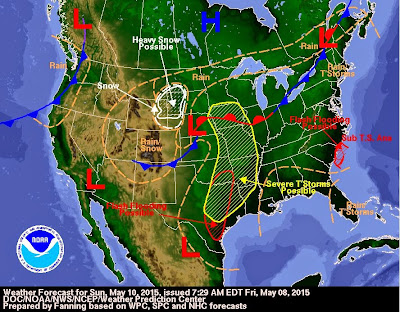
Today has been gray and cooler than yesterday. There were a few breaks in the clouds to see sunnier skies earlier in the afternoon around 12:30 pm but the sky was quickly covered again by stratus clouds. The humidity is very high and it is likely that it will rain later this evening, with a chance for passing thunderstorms. The winds are coming from the south and east which is keeping temperatures pretty stable until Tuesday when the winds will begin to shift to coming from the north. We could expect a pretty cold evening Tuesday with lows dropping to the mid 30s. A low pressure system tied to a stationary front and a cold front will also contribute to the stable and then cold temperatures, and high chance for precipitation tonight and all day tomorrow. Monday should be in the mid 60s, rainy, and windy with strong gusts.


May 8, 2015

Day 79

Temperature: 61.3 °F,  feels like 61.3 °F
Humidity: 70%
Dew Point: 52 °F
Wind: 3.1 mph W with 6 mph gusts
Pressure: 29.96 in
Visibility: 10 miles
Cover: Overcast 1700 ft
Observation: 12:30 PM
Moon: Waning Gibbous 79% 
visible


Source: http://wxug.us/19tg2

Today is cool and gray out and pretty humid. The winds are coming in from the west right now but through the course of the day they are going to switch to coming from the north which will keep the temperatures cool today. The northern winds will bring a high pressure system down from Canada which will give us a sunny and warmer day tomorrow. There is a pocket of snow over the Rockies that will become rain by the time it reaches us on Sunday because of the warm front it will be passing through. Tomorrow will be sunny and clear with temperatures in the mid 70s.


May 6, 2015

Day 78

Temperature: 77.9 °F,  feels like 79 °F
Humidity: 55%
Dew Point: 59 °F
Wind: 0.7 mph S with 10 mph gusts
Pressure: 29.93 in
Visibility: 10 miles
Cover: Partly Cloudy 
Observation: 6:30 PM
Moon: Waxing Gibbous 92% 
visible


Source: http://wxug.us/19tg2

There have been rain storms passing through the area all day. This morning it was a little cool and sunny but by 11:30 am we had completely cloudy skies and rain showers for about an hour. Then it burned off and it was super sunny, humid, and hot for a few hours. Now the clouds have returned and the humidity has been rising for the past hour or two. I expect the next batch of showers to arrive within the next hour or so. It should be an intense but short thunderstorm. Right now it looks like the interesting part will be to the south of us unless the southerly winds that brought the hot humid air earlier pick up and push the storm further north. The cold front/stationary front to the west of us will bring stronger thunderstorms to our area tomorrow evening and into the nighttime hours.


May 5, 2015

Day 77

Temperature: 67.6 °F,  feels like 67.6 °F
Humidity: 36%
Dew Point: 379°F
Wind: .7 mph SSE with 6 mph gusts
Pressure: 30.17 in
Visibility: 10 miles
Cover: Overcast 6000 ft
Observation: 6:30 PM
Moon: Waxing Gibbous 97% 
visible


Source: http://wxug.us/19tg2

Today started out much cooler but then the air temperature increased steadily through the morning to hit our high temp of 71°F. Since noon there has been increasing cloud cover and stronger wind gusts. Minnesota and Wisconsin are currently situated between two parallel bands of stationary fronts with a precipitation path of rain running between the fronts. We have a low (less than 50%) chance of rain throughout tonight and tomorrow. By Thursday the tail end of the stationary front that is tied to a cold front and a bunch of low pressure sports will make its way to us and we should expect at least rain and perhaps a thunderstorm in the evening/early nighttime hours. The next two days should be pretty warm (late 70s) because the stationary fronts are blocking other air masses from interfering and keeping the warm air over us. 


May 4, 2015

Day 76

Temperature: 72 °F,  feels like 74 °F
Humidity: 17%
Dew Point: 25 °F
Wind: .7 mph E with 6 mph gusts
Pressure: 30.14 in
Visibility: 10 miles
Cover: Clear
Observation: 4:30 PM
Moon: Waxing Gibbous 99% 
visible


Source: http://wxug.us/19tg2

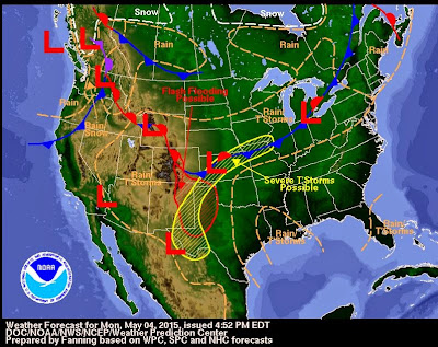
Today has been warm and sunny with a hazy layer of altostratus clouds that have accumulated over the past few hours. The air temperature is cooler than yesterday after the storm we had last night that was brought in on a cold front. The storm came in around 6 pm to Eau Claire and the skies had a light green tinge to them. It was extremely windy with the rain blowing sideways at some points. We got about an inch of rain in a little over an hour which caused minor flooding on sidewalks and street corners. We were under a severe weather warning and the city sirens did go off, but the storm didn't seem as strong as they were anticipating. I didn't see the ping pong ball sized the weatherman was predicting anyway. 

Tonight and tomorrow should be about the same as today. In the overnight hours we may have a slight chance for rain, but any substantial precipitation likely won't come until Wednesday when we have a chance for another thunderstorm. 


May 3, 2015

Day 75

Temperature: 84.9 °F,  feels like 83 °F
Humidity: 34%
Dew Point: 54 °F
Wind: 3.1 mph S with 5.4 mph gusts
Pressure: 29.73 in
Visibility: 10 miles
Cover: Clear
Observation: 5:30 PM
Moon: Full 100% 
visible

Source: http://wxug.us/19tg2

Yesterday and today have been bright and sunny with a warm breeze and passing mid altitude clouds. This morning there was a mixed sky with altocumulus and altostratus clouds but they burned off a few hours ago. There is currently a pocket of potentially severe thunderstorms coming our way, but you wouldn't really know it with the clear and sunny skies we have here right now. The chance for the storms to hit us has been fluctuating rapidly for the last couple days and now continues to change by the hour. It may burn out before it hits us, or decrease in severity. Tomorrow will be cooler than today, especially if we do get that rain, but still bright and sunny like today with a high of 75 °F.

May 1, 2015

Day 74

Temperature: 73.9 °F,  feels like 76 °F
Humidity: 27%
Dew Point: 39 °F
Wind: 2.2 mph N with 7.6 mph gusts
Pressure: 30.08 in
Visibility: 10 miles
Cover: Overcast
Observation: 12:30 PM
Moon: Waxing Gibbous, 94% visible


Source: http://wxug.us/19tg2


This morning was pretty sunny and clear but in the last two hours or so, it has become increasingly cloudy and now there is a near solid cover of light gray high altitude clouds. There was a spike in temperature earlier hitting around 73 °F but the temperature has been slowly declining with the cloud cover. The cause for this was a warm front that passed through quickly and is being replaced with a cold front that has moisture and rain coming from the North/northwest. There is currently a 20% chance the rain will actually fall in our area, but the cloud cover and moisture will be sticking around and raising ground temperatures tonight and into tomorrow. This build up of energy along with combating fronts will likely produce a thunderstorm on Sunday afternoon evening. Can't wait!